The design of Ontario Place’s public realm is an iterative process, and the design team has been working to address feedback received to date from the public, stakeholders and Indigenous communities.
Since Fall 2022, the design team has developed a recommended design for the public realm spaces at Ontario Place based on the EA evaluation of the concepts and feedback from the public, Indigenous communities and stakeholders. This station of the Virtual Public Engagement Room will show the design concepts that were presented in Fall 2022, give a summary of the evaluation of the concepts, and explore the preferred design for each zone with you. At the end of this station, all of the zones are brought together to present an overall recommended design for the public realm and shows how it integrates with the tenant developments. The recommended design presented in this station is subject to change and refinement based on feedback that was received during the April 27th live event and through this virtual public engagement room. While the design is intended for the redevelopment of Ontario Place’s public realm, it does not preclude future development opportunities from being considered on site.
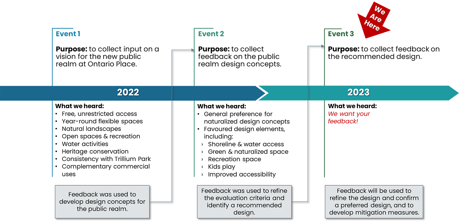
How we got here & what we heard
Consultation and engagement with Indigenous communities
In addition to public engagement, consultation and engagement with rights-holding Indigenous communities and urban Indigenous organizations in Toronto has been ongoing and will continue throughout the EA and design process. Shelley Charles of Minokamik, a collective of Elders, knowledge holders, horticulturalists and environmental stewards, is the Indigenous Engagement Project Lead. She has been facilitating Indigenous engagement meetings and discussing ways to celebrate the distinct historical, cultural, environmental and educational contributions of Indigenous people at Ontario Place. Suggestions for the public realm design shared by Indigenous community members include:
- Using native trees and species
- Working with, not against nature
- Using of plants (i.e., water lilies) to filter out toxins in water
- Replacing impervious with pervious material where possible
- Sharing and teaching of Traditional Ecological Knowledge
- Leaving space for the natural world and for wildlife to exist without human interference
- Including linguistic diversity
- Including wampum belt teaching and symbolism
- Storytelling
*The above list only represents a few of the ideas discussed during engagement sessions and will be further considered during detail design.
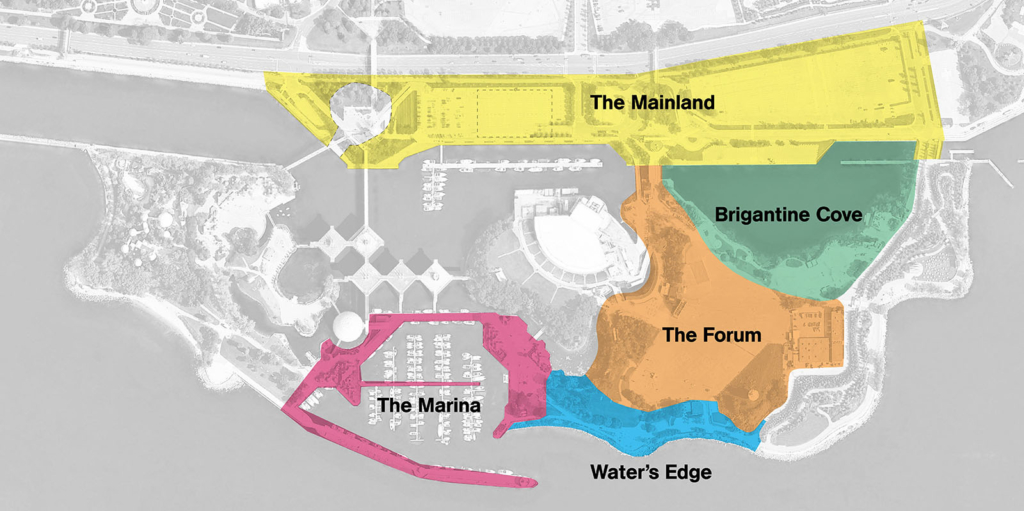
The zones
The five zones are the key spaces that define the character of Ontario Place and are captured by the current EA process.

Zone 1: Water’s Edge
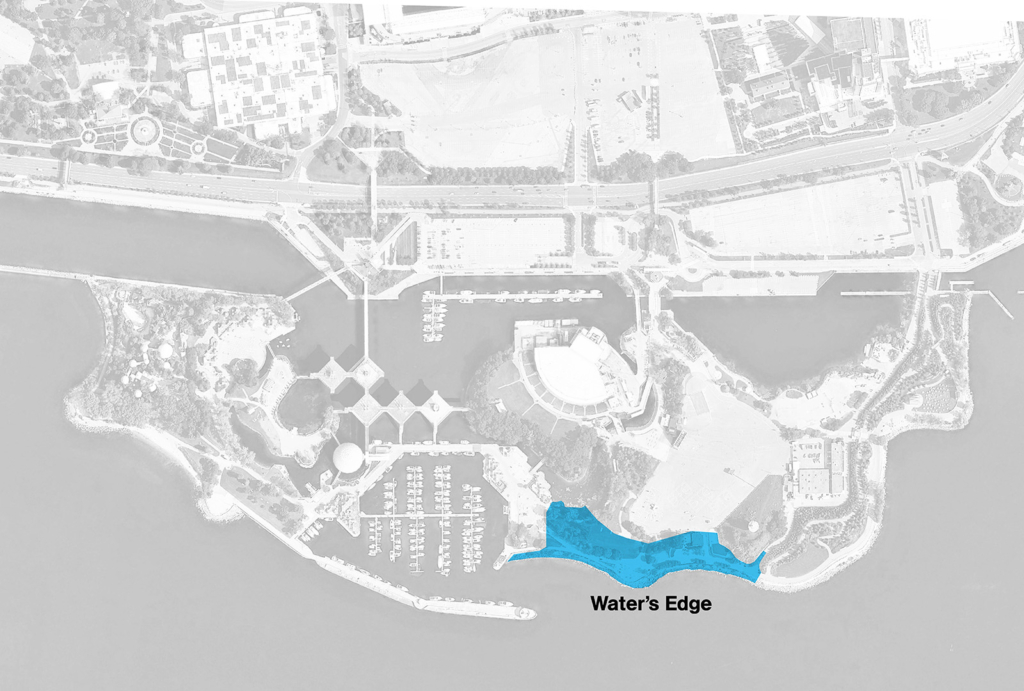
Water’s Edge: The concepts
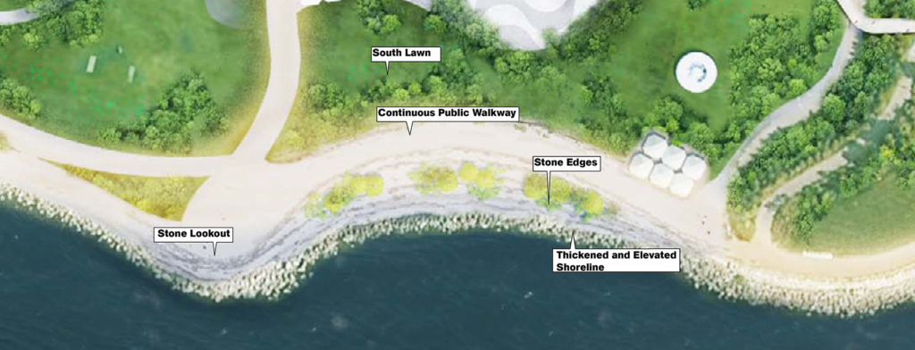
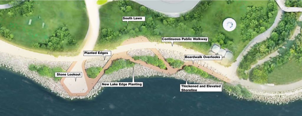
The two concepts that were shared for the Water’s Edge in Fall 2022 and that were evaluated through the EA process are:
Water’s Edge: What we heard
✓ Maximize natural areas
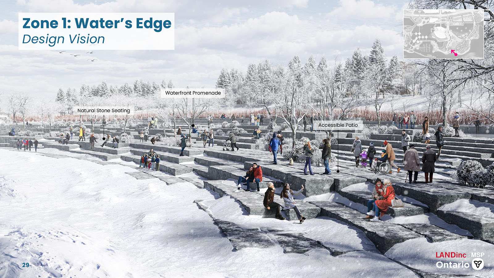
✓ Design for year-round, all-season access
✓ Increase access to the water’s edge
✓ Shaded seating and picnic opportunities
✓ Include accessibility for all ages and abilities
Water’s Edge: The evaluation
| Category | Concept A: Stone Lookouts | Concept B: Planted Piers |
|---|---|---|
| Natural Environment | Preferred | Less Preferred |
| Social Environment | Preferred | Less Preferred |
| Cultural Environment | Preferred | Preferred |
| Technical Environment | Less Preferred | Preferred |
| Economic Environment | Preferred | Preferred |
| Sustainability | Preferred | Less Preferred |
| Overall Preference | Preferred | Less Preferred |
Concept A provides greater opportunity for long-term shoreline protection, integrates Hough principles, and allows for additional seating along the shoreline. This concept is being modified to make the lower waterfront accessible to all users and will increase vegetation to the extent possible. A summary table of the evaluation of the design concepts for the Water’s Edge can be viewed here.
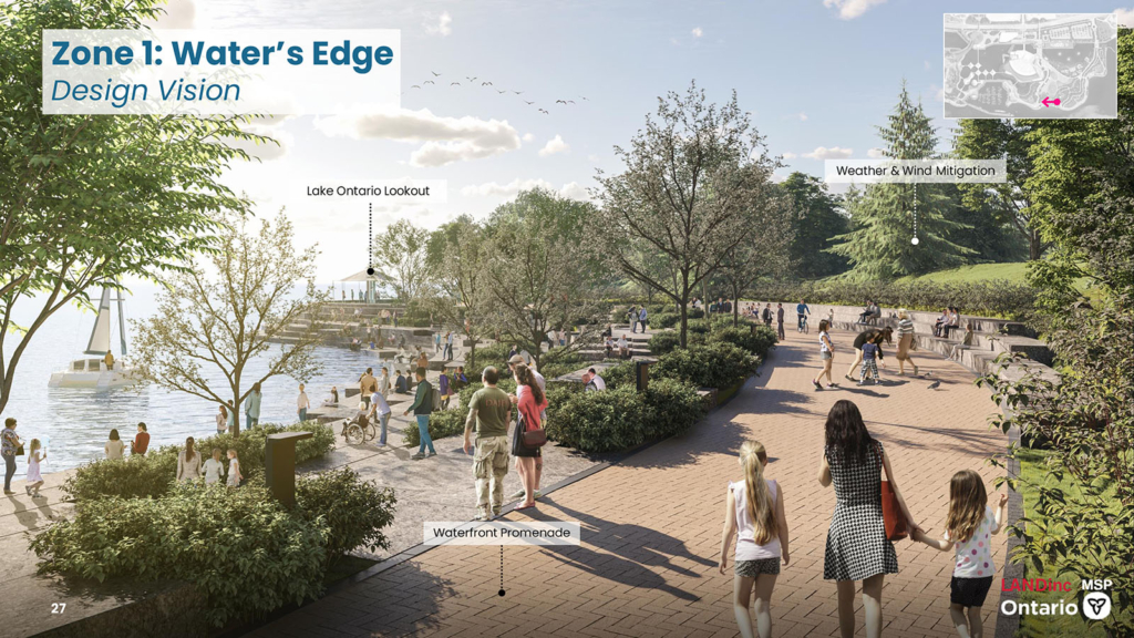
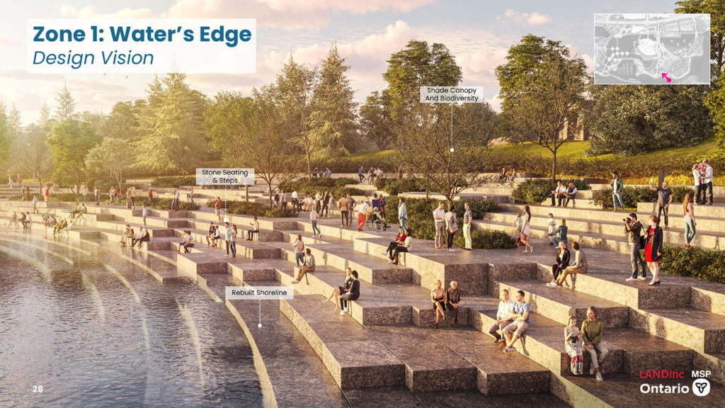
Water’s Edge: The recommended design
Designs for flooding and wave up-rush occurrences are extremely important for public safety along the south shore. The recommended design achieves this by pulling the water’s edge further into the island to create a gradual series of terraces down to the water with the goal of creating a generous park space that faces the lake. Restoration of the south shore provides the opportunity to have stone terraces down to the water which create stone piers to view and interact with the water’s edge. Stone piers of different sizes are included to allow families to use and claim them for the day. Some piers are big enough for a dozen people, some are smaller and more intimate for a gathering of 4-6.
Feedback/Comment
This section is now closed.
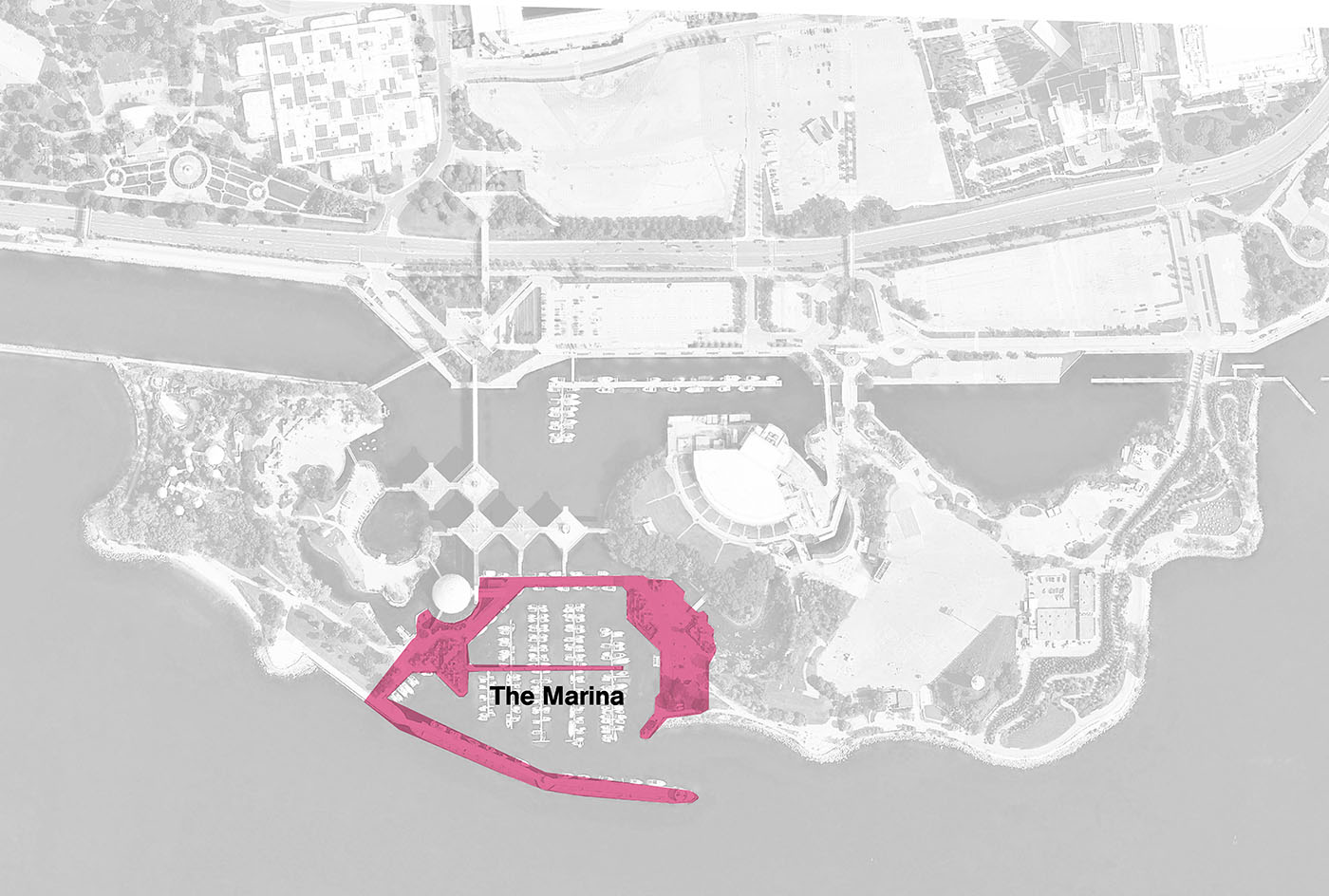
Zone 2: Marina
Marina: The concepts
The two concepts that were shared for the Marina in Fall 2022 and that were evaluated through the EA process are:
Marina: What we heard
✓ Local and affordable commercial vendors
✓ Maximize public access
✓ Safe water access
✓ Shaded seating and nighttime lighting
✓ Increase green space
Marina: The evaluation
| Category | Concept A: Park Marina | Concept B: Ontario Port |
|---|---|---|
| Natural Environment | Preferred | Less Preferred |
| Social Environment | Preferred | Less Preferred |
| Cultural Environment | Less Preferred | Preferred |
| Technical Environment | Preferred | Preferred |
| Economic Environment | Preferred | Preferred |
| Sustainability | Preferred | Less Preferred |
| Overall Preference | Preferred | Less Preferred |
Concept A provides more opportunity for increasing vegetation and greenspace. Public feedback has indicated a preference for the features associated with Concept A. Ideas from both concepts will be integrated, including maximizing greenspace, educational opportunities, areas for future commercial use, shaded seating, and the Cultural Pavilion. A summary table of the evaluation of the design concepts for the Marina can be viewed here.
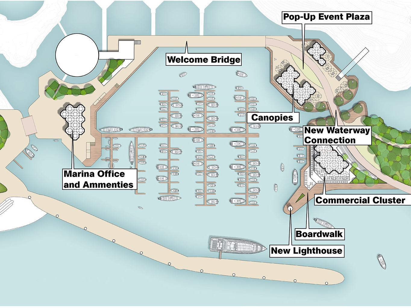
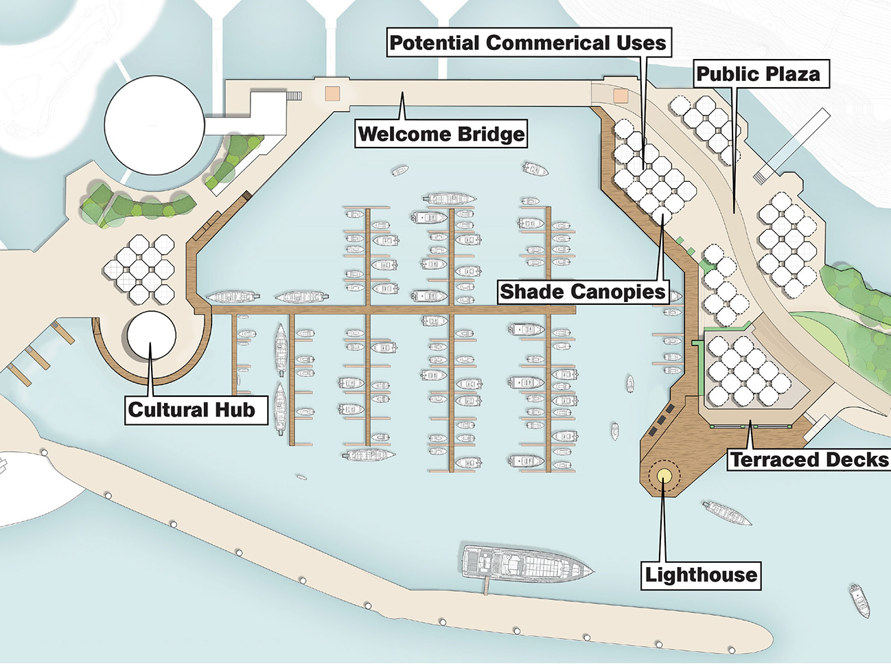
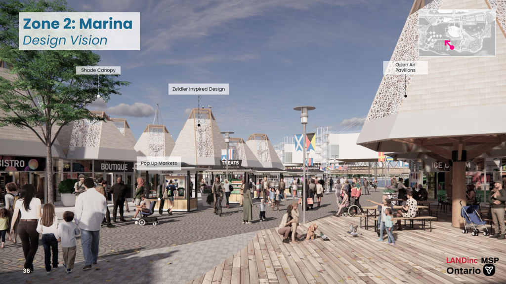
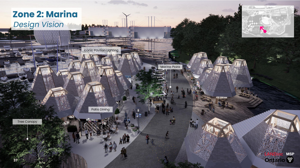
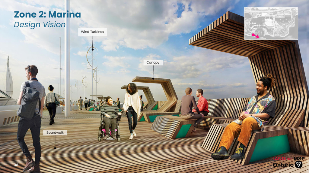
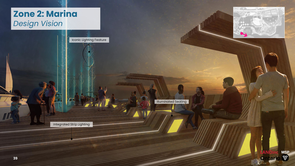
Marina: Recommended design
The recommended design for this zone features open air park pavilions, commercial opportunities for cafes and restaurants, as well as flexible plaza spaces for a variety of public events and activities. A prominent boardwalk connects the east and west marina including a series of boardwalks that come closer to the water’s edge. Expansion of the lighthouse pier creates an enhanced plaza space for viewing the Pods, the Cinesphere and passing boats. The Breakwater Sunset Pier will be a new exciting meeting place morning, day and night. It will also accommodate ferries and small ships to receive visitors via lake transportation.
Feedback/comments
This section is now closed.
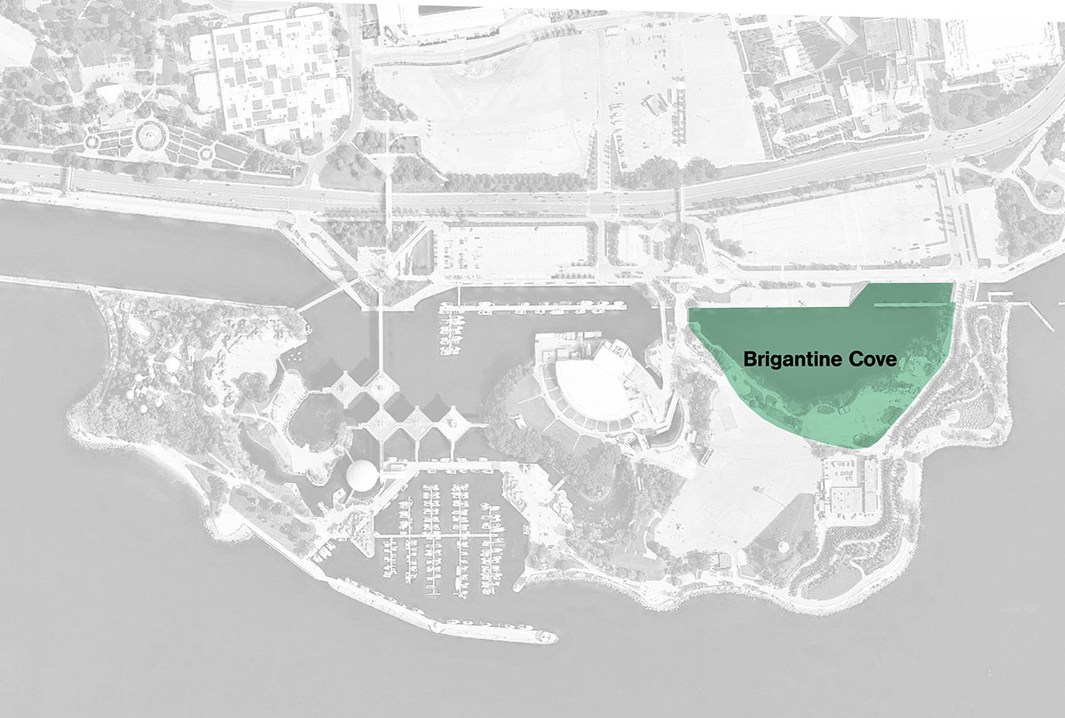
Zone 3: Brigantine Cove
Brigantine Cove: The concepts
The two concepts that were shared for Brigantine Cove in Fall 2022 and that were evaluated through the EA process are:
Brigantine Cove: What we heard
✓ Provide an ‘escape’ from the city
✓ Improve water quality and circulation
✓ Provide access to the water
✓ Create green areas with native trees and plants
✓ Build an innovative children’s play area
Brigantine Cove: The evaluation
| Category | Concept A: Event & Activities | Concept B: Wetland & Nature |
|---|---|---|
| Natural Environment | Less Preferred | Preferred |
| Social Environment | Less Preferred | Preferred |
| Cultural Environment | Less Preferred | Preferred |
| Technical Environment | Less Preferred | Preferred |
| Economic Environment | Preferred | Less Preferred |
| Sustainability | Less Preferred | Preferred |
| Overall Preference | Less Preferred | Preferred |
Concept B provides opportunity for park users to interact with the environment via boardwalk and wetlands, more vegetation, greenspace and a Children’s Play Zone, while providing effective and sustainable stormwater management protecting against flood risks. A summary table of the evaluation of the design concepts for Brigantine Cove can be viewed here.
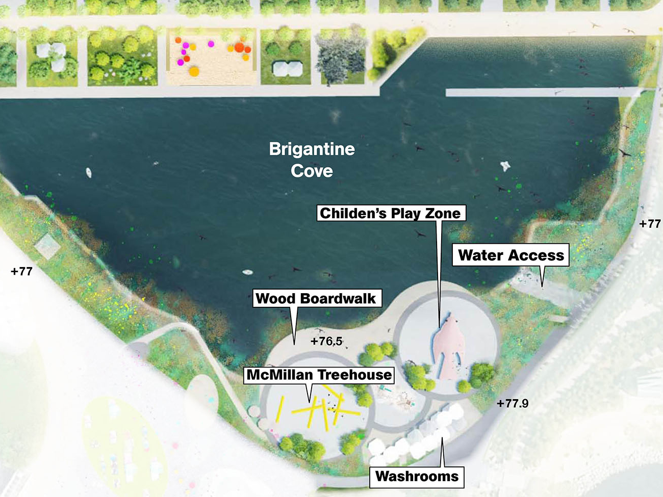
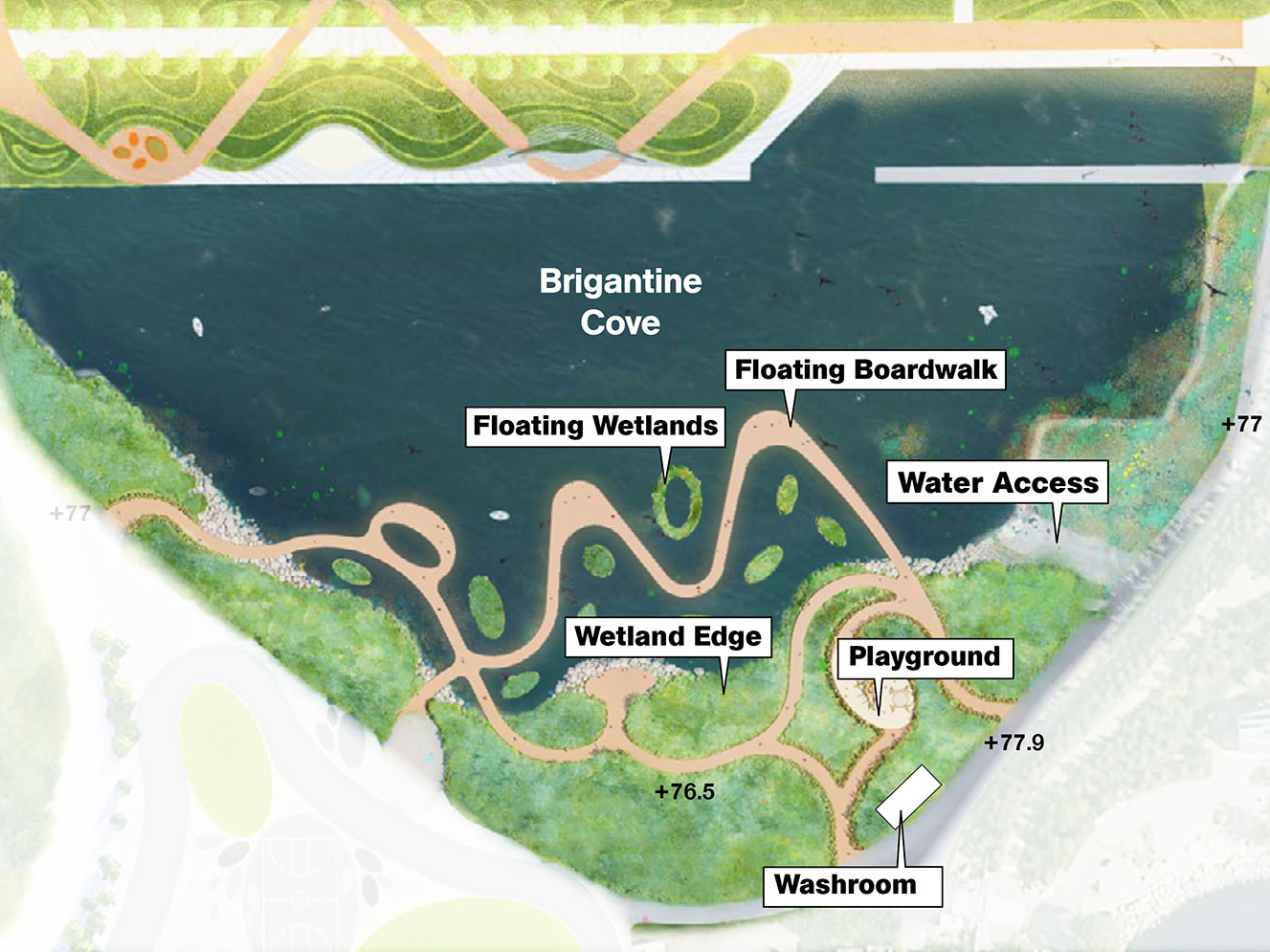
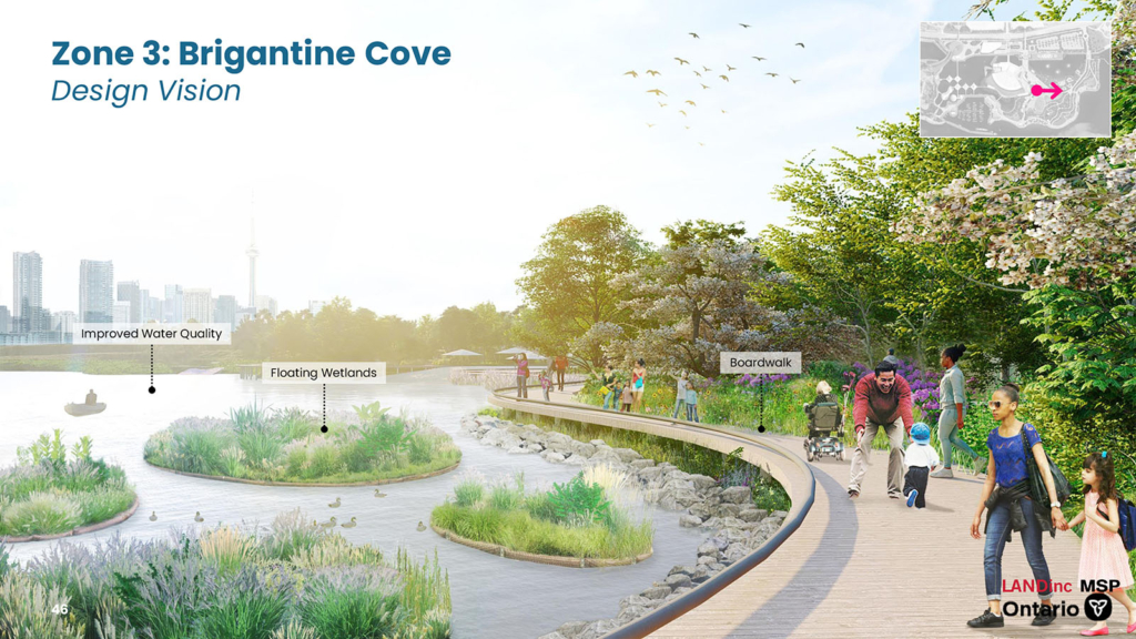
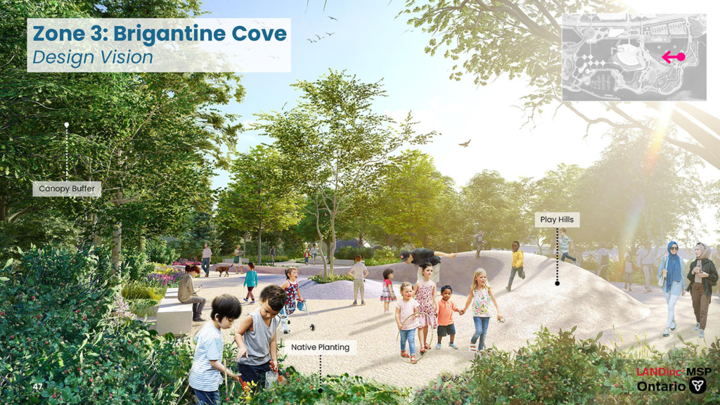
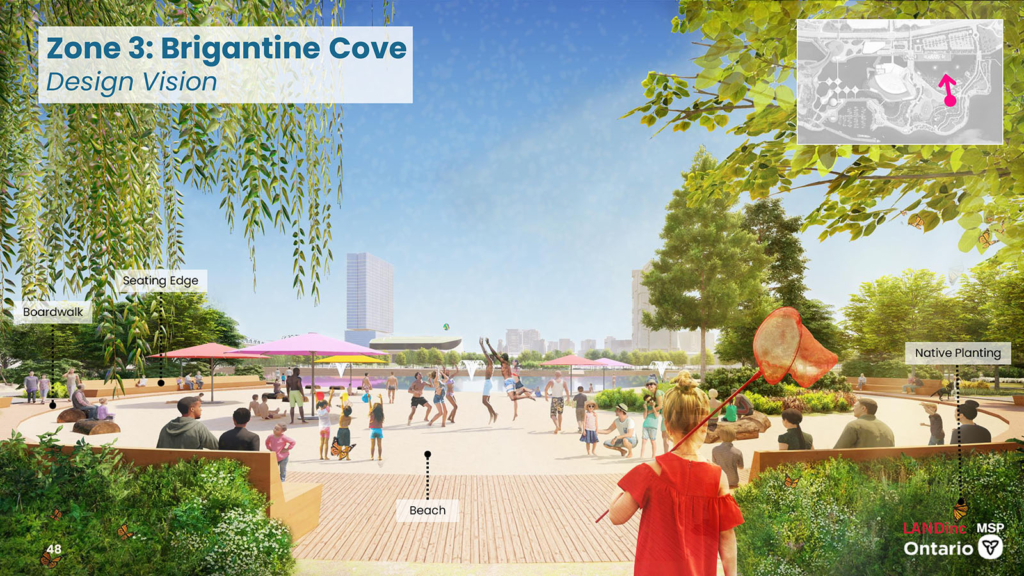
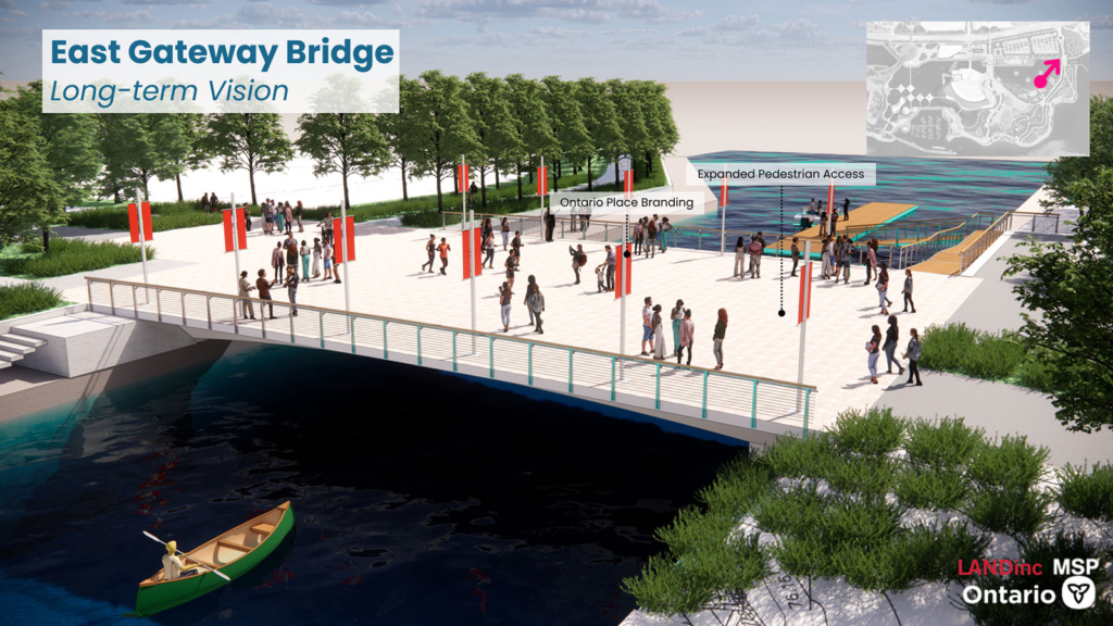
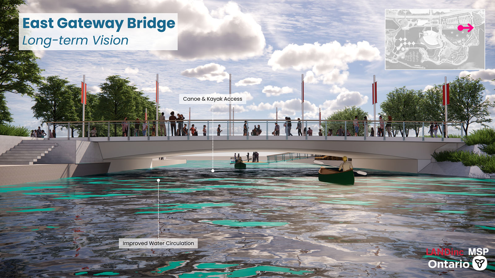
Brigantine Cove: The recommended design
The recommended design for Brigantine Cove (the cove) seeks to unify the space and create a more natural environment. This will help boost water quality and provide a park-like setting for the cove. The cove design provides space for children’s play inspired by Indigenous storytelling. A small beach area is provided in the center of the cove which creates a flexible play space for all ages to enjoy. Floating wetlands create a green edge along the cove and provide refuge and spawning habitat for aquatic species. The East Bridge is a key feature for allowing canoes and kayaks to pass through the cove while improving water quality and circulation within the cove. Fountains here also improve water circulation while creating an iconic water feature. Supporting amenities, such as washroom and changing room, are also included in the design for this zone.
Feedback/comments
This section is now closed.
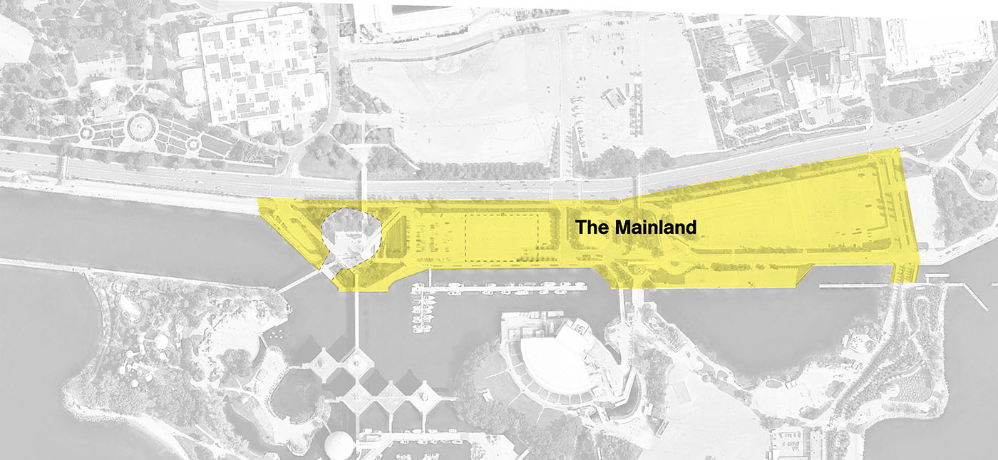
Zone 4: Mainland
Mainland: The concepts
The two concepts that were shared for the Mainland in Fall 2022 and that were evaluated through the EA process are:

Mainland: What we heard
✓ “Green” the currently paved areas
✓ Accessibility for all ages and abilities
✓ Improve walking and bicycling connections
✓ Provide recreational opportunities
✓ Improve transit connections
Mainland: The evaluation
| Category | Concept A: Urban & Active | Concept B: Green Gateway |
|---|---|---|
| Natural Environment | Less Preferred | Preferred |
| Social Environment | Preferred | Preferred |
| Cultural Environment | Less Preferred | Preferred |
| Technical Environment | Preferred | Less Preferred |
| Economic Environment | Preferred | Less Preferred |
| Sustainability | Preferred | Preferred |
| Overall Preference | Preferred | Less Preferred |
Concept A has lower construction and maintenance costs and is easier to implement. Features from Concept B will be integrated, such as increasing greenspace and vegetation. A summary table of the evaluation of the design concepts for the Mainland can be viewed here.
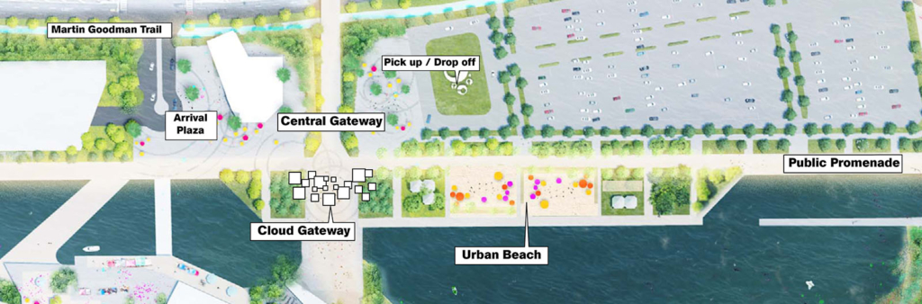
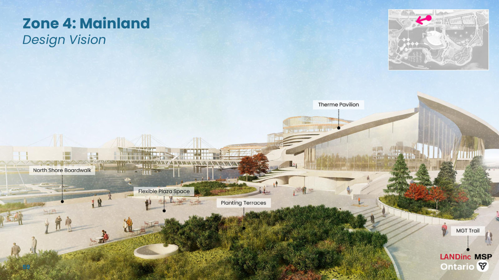
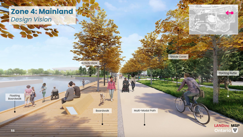
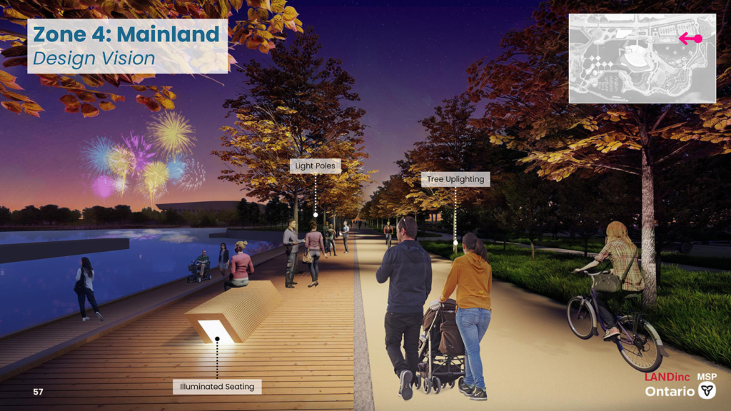
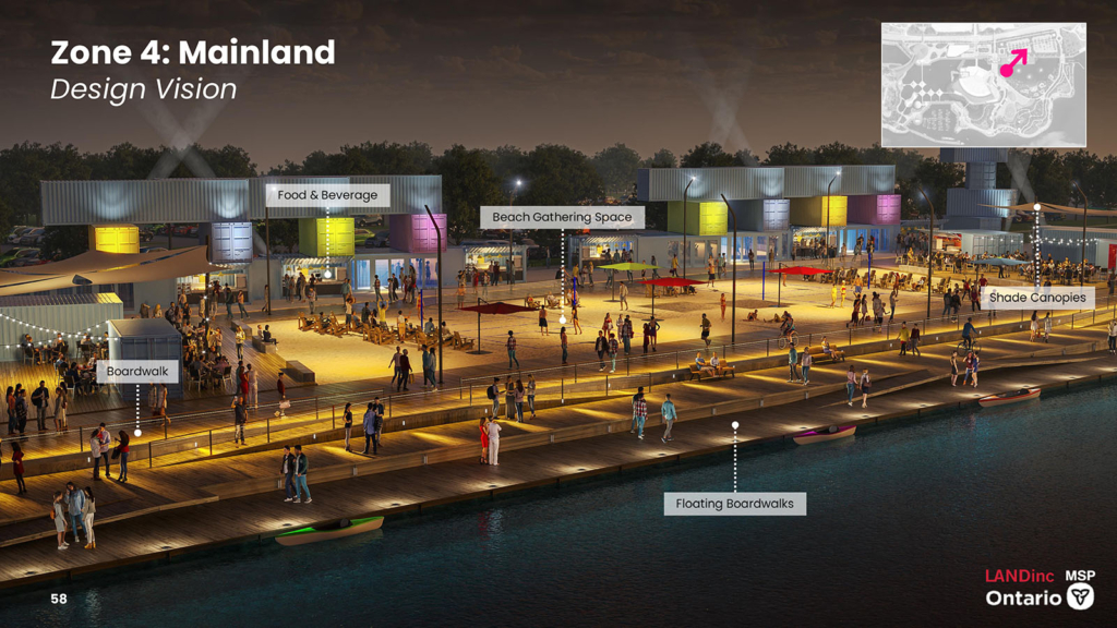
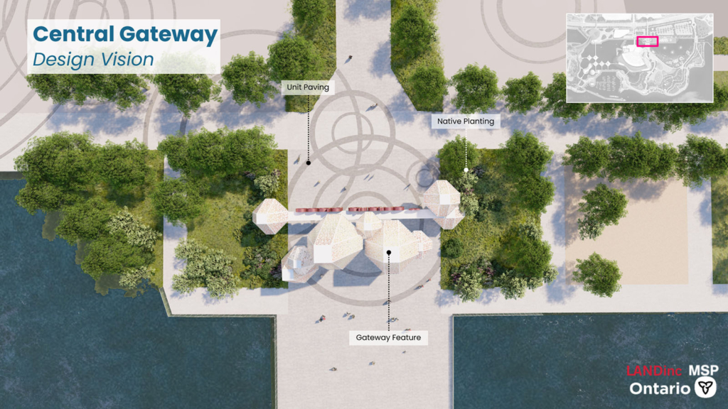
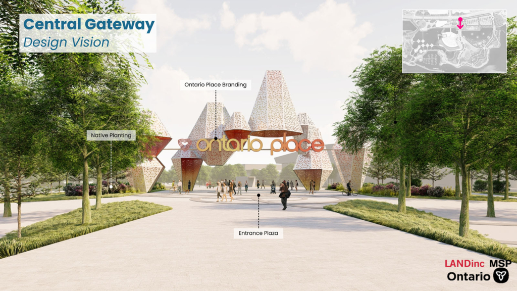
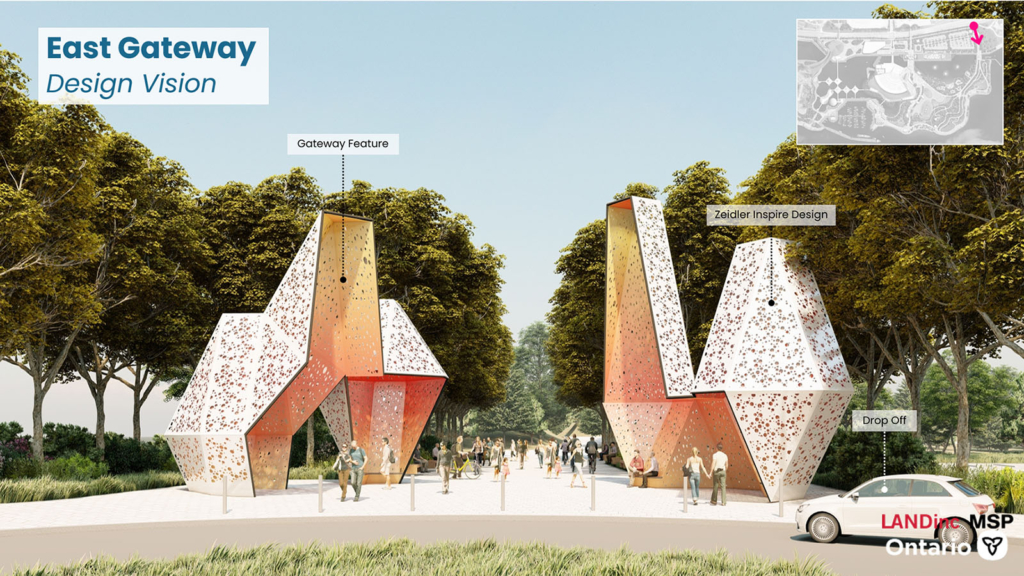
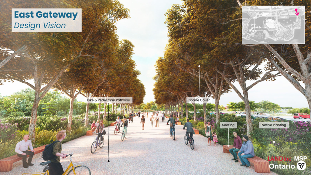
Mainland: The recommended design
The Mainland zone is an active hub for food and beverage as well as flexible public plaza spaces with key points of arrival to Ontario Place. The north shore promenade connects east and west of Ontario Place with a multi-mode pedestrian path. This path goes through the Cabana market located just south of the surface parking lot. Food and beverage is proposed along the edges of an active central beach where people can relax and look over Brigantine Cove. The Mainland is also a key hub for pick up and drop off as well as a public bus loop that brings people into Ontario Place. The mainland has multiple plaza and flex spaces, and Ontario Plaza is anticipated to be one of the most active as it sits between the Therme pavilion and the potential science programming pavilion. This design also widens the Martin Goodman Trail along Lakeshore Boulevard, creating a safer environment for both cyclists, joggers, and pedestrians.
Parking
While parking is part of the Mainland zone, parking alternatives were identified separately from the Mainland design concepts. The key reason for taking this approach is that parking is required regardless of the design concept selected and is not part of the evaluation of Mainland design concepts. The parking solution considered should meet the following project objectives:
- Not limit or negatively impact new public spaces on Ontario Place
- Protect the heritage view of Pods and Cinesphere from Lake Shore Boulevard West
- Meet municipal policies for waterfront development
- Allow for increased provision of parking to meet projected demand
To help meet these objectives, parking alternatives considered included location and structure type. The parking location alternatives were an onsite parking facility or an offsite parking facility. Given the location of Ontario Place, the only alternative considered for offsite parking was the existing parking at Exhibition Place, which has been used for overflow parking during large events held at Ontario Place. The following parking structure alternatives were identified:
- An aboveground structure
- A belowground structure
- Surface parking lots
- A combination of a surface parking lot and a belowground structure
Parking evaluation
A two-step process was followed to determine the recommended parking alternative to address the parking needs identified for redevelopment of Ontario Place. The approximate number of spaces required is 2,600 to 2,800, which includes consideration for shared parking between the various uses of Ontario Place (such as, Therme, the public realm, Live Nation) and Transportation Demand Management (policies and programs to influence how people choose to travel with the aim to reduce single-occupant vehicle trips by encouraging more sustainable forms of transportation (such as, transit, cycling)).
In both Steps One and Two, alternatives were developed and evaluated against the following criteria (under five categories):
| Category | Criteria |
|---|---|
| Natural Environment | Impacts to existing terrestrial species and aquatic environment. Ability to revegetate existing parking lots. |
| Social Environment | Traffic impacts on Lake Shore Boulevard West. Impacts to parking lot users (such as, fees, proximity). Ability to access Lake Shore Boulevard West and Ontario Place. |
| Cultural Environment | Compatibility with existing cultural heritage attributes. |
| Technical Environment | Ability to integrate redevelopment opportunities. Constructibility. Flexibility in parking lot sizing. |
| Economic Environment | Capital cost. Operational and maintenance costs. Construction related costs. |
Step One requires an initial assessment of parking facilities onsite versus offsite at Ontario Place. Given the location of Ontario Place, the most likely off-site parking alternative available was Exhibition Place, which has been used for overflow parking during large events held at Ontario Place. Exhibition Place is undergoing a master plan exercise that is focused on active transportation, part of this process includes reviewing the parking supply and thus it cannot be assumed that a permanent parking supply will be available for Ontario Place users. The result is undertaking a screening process (that takes this information into consideration) to determine the preference for the parking location.
Download Step One Parking Evaluation
This evaluation resulted in onsite as the preferred solution.
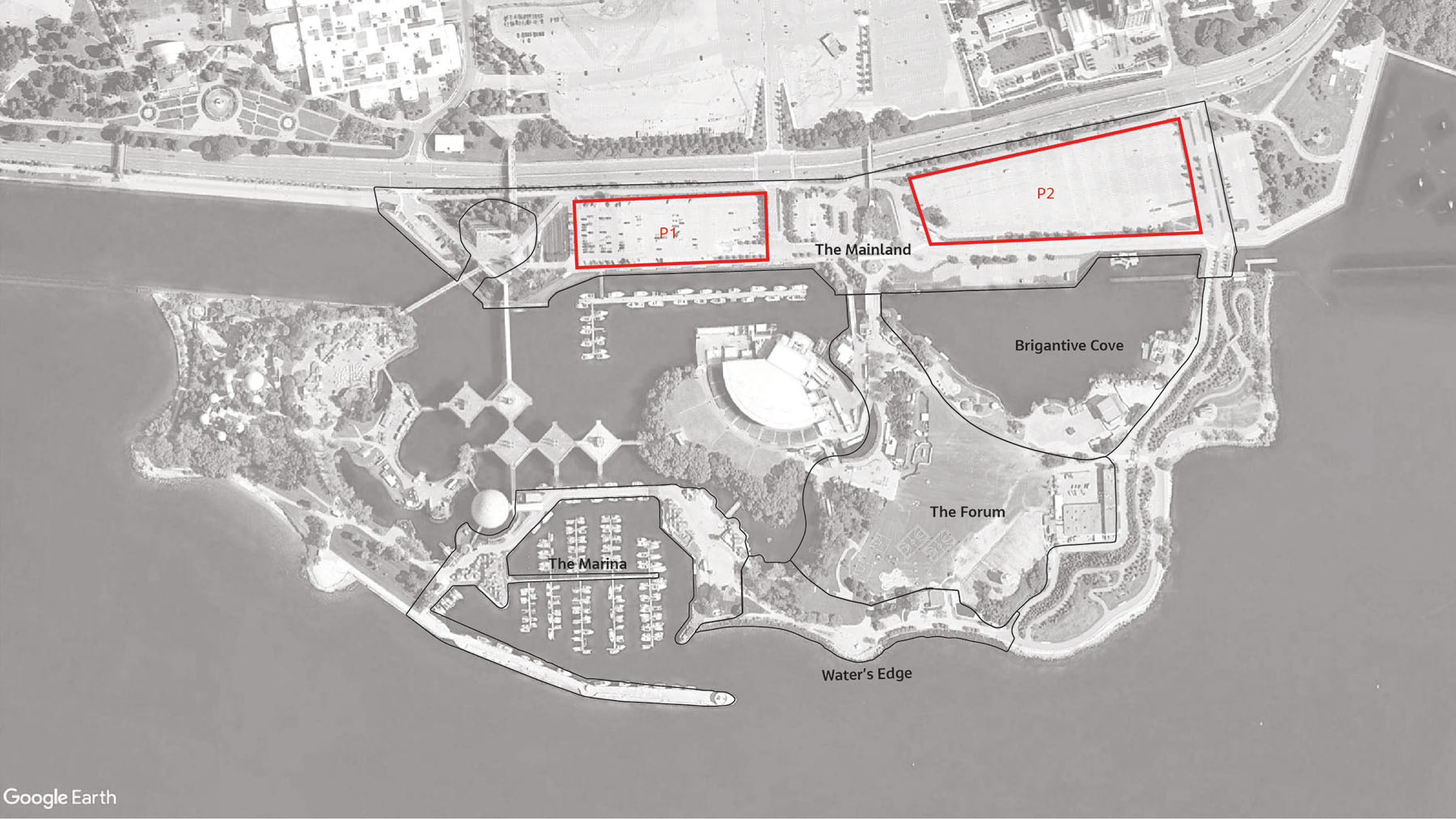
Step Two consists of a comparative evaluation of parking structures to determine which is recommended to meet the future parking demand requirements. The evaluation looked at the opportunity for construction of parking structures on P1 and P2 within the Mainland zone of Ontario Place. The result of Step One was the selection of onsite parking as the recommended option for parking. The benefits of the selection of onsite parking at Ontario Place (such as, owned by the Province, parking revenues to the Province) is carried forward from the results of Step One. The five categories were used to evaluate the alternatives with selection of the recommended alternative.
Download Step Two Parking Evaluation
| Category | Above ground structure | Below ground structure | Surface parking lots | Combination of surface and below ground |
|---|---|---|---|---|
| Natural Environment | Least Preferred | Preferred | Less Preferred | Preferred |
| Social Environment | Preferred | Less Preferred | Least Preferred | Less Preferred |
| Cultural Environment | Least Preferred | Preferred | Preferred | Preferred |
| Technical Environment | Least Preferred | Less Preferred | Least Preferred | Preferred |
| Economic Environment | Least Preferred | Less Preferred | Preferred | Less Preferred |
| Overall Preference | Least Preferred | Less Preferred | Least Preferred | Preferred |
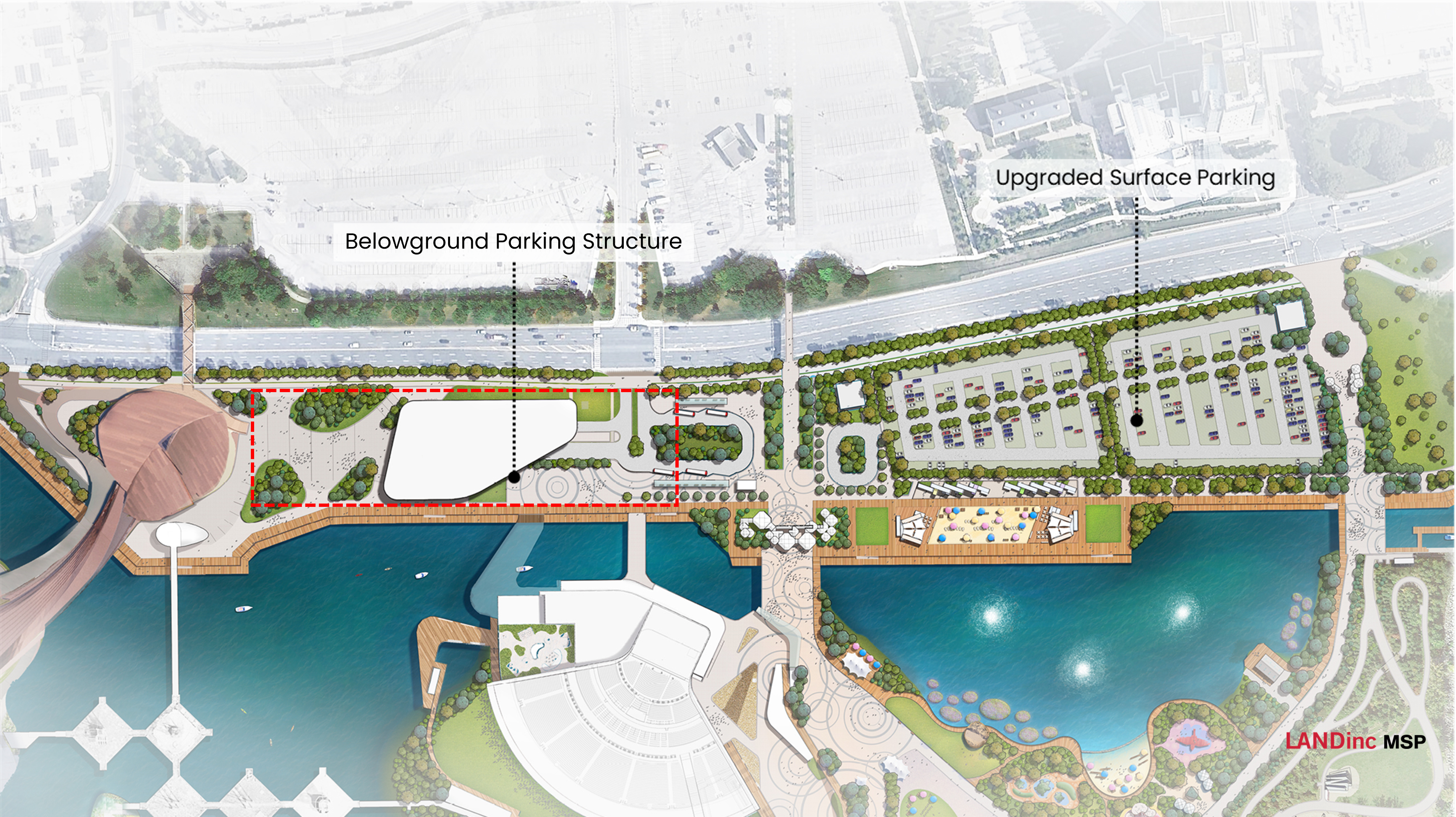
Combination of surface parking lot and belowground structure provides greatest onsite parking and flexibility in parking options for visitors. Maintains heritage views and views of Lake Ontario, opportunity for future development of west side of Mainland (including revegetation) and lower operating and maintenance costs.
Parking recommended alternative
As shown in the evaluation tables linked above, the recommended alternative for the parking is to have a combination of surface parking and a below ground parking structure on-site within the Mainland zone.
Ontario Science Centre
The Ontario Science Centre (OSC) will move to Ontario Place, creating a new state-of-the-art facility to welcome local visitors and tourists from across the province and around the world.
The OSC relocation will bring exciting, family-friendly science-based educational programming to Ontario Place, including to the five historic Pods and Cinesphere. Functional requirements for the new OSC were established by Lord Cultural Resources, in consultation with the OSC, with the goal of achieving both the OSC’s modernization and sustainability objectives. To deliver its mandate and programming, the OSC will require approximately 200,000ft2 on the mainland in a brand new state-of-the-art building, plus an additional 75,000ft2 in the modernized Pod and Cinesphere complex, for a total size of 275,000sf – supported by brand new exhibits for all ages.
While the detail design for the new OSC main building will be developed through a subsequent design process, several conceptual alternatives have been evaluated as part of this Category C Class EA to help determine potential impacts and develop mitigation measures to guide future design development. Alternatives considered include:
- Location: Mainland (P1), Mainland (P2)
- Height and Massing: Low (maximum 2 storeys; up to 80% P1 site coverage); Medium (3 to 6 storeys; up to 55% P1 site coverage); Tall (7 plus storeys; up to 25% P1 site coverage)
Ontario Science Centre evaluation
The OSC main building alternatives were evaluated separately from the evaluation of the Mainland zone design concepts.
Alternatives were developed and evaluated against a series of high-level objectives including the ability to accommodate the functional and operational requirements for the OSC’s science-based educational programming and the need to incorporate the adaptive reuse of the existing Pods and Cinesphere. In addition, alternatives were assessed and evaluated against the following criteria:
| Category | Criteria |
|---|---|
| Natural Environment | Impacts to existing terrestrial species and wildlife habitat. |
| Social Environment | Access to Lake Shore Boulevard West, transit and parking. Impacts on public space. Ability to serve as a gateway or landmark to Ontario Place. |
| Cultural Environment | Compatibility with existing cultural heritage attributes. |
| Technical Environment | Ability to accommodate functional program requirements (size, circulation between spaces, adjacency, etc.). Constructibility. Ability to integrate with the Pods and Cinesphere and existing bridge. |
| Economic Environment | Capital cost. Operational and maintenance costs. |
A two-step process was followed to determine the recommended OSC alternative. Step one included evaluating the location alternatives. Based on the space required to accommodate the delivery of science programming, existing lease agreements with other partners for sections of the site, and proposed public realm improvements, feasible location alternatives for the OSC at Ontario Place include:
- Mainland (P1)
- Mainland (P2)
Download OSC location alternative evaluation table.
| Category | Mainland (P1) | Mainland (P2) |
|---|---|---|
| Natural Environment | Preferred | Preferred |
| Social Environment | Preferred | Less Preferred |
| Cultural Environment | Preferred | Preferred |
| Technical Environment | Least Preferred | Less Preferred |
| Economic Environment | Least Preferred | Less Preferred |
| Overall Preference | Preferred | Less Preferred |
The evaluation shows a clear preference for P1, which is the location west of the central gateway.
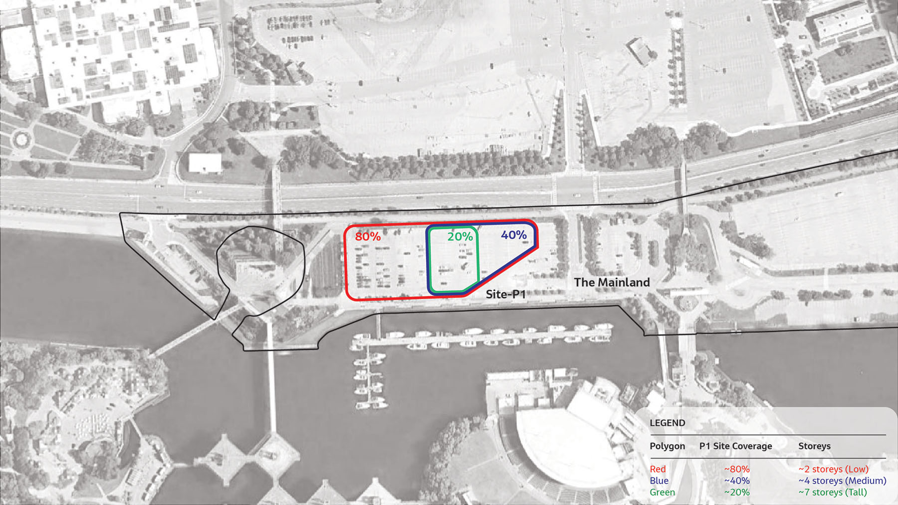
Step two evaluated built form alternatives including building height and massing. The functional program establishes that the OSC requires an approximate gross floor area (GFA) of 200,000 ft2 (in addition to the Pods and Cinesphere at 75,700 ft2). This GFA could theoretically be accommodated in a variety of built forms, from a low rise building with a larger footprint to a tall slender building, or something in between. A key consideration in the evaluation of height and massing alternatives, however, is the need to maximize the efficiency of the building based on access, adjacency, and circulation between spaces. Based on the space available at the recommended location (P1) (as shown on the above map), the following height and massing alternatives were evaluated:
– Low (maximum 2 storeys; up to 80% P1 site coverage)
– Medium (3 to 6 storeys; up to 55% P1 site coverage)
– Tall (7 plus storeys; up to 25% P1 site coverage)
The image below shows an example footprint for a low, medium, and tall alternative.
Download OSC height and massing evaluation table.
| Category | Low (up to 2 storeys; P1 site coverage up to 80%) | Medium (3 to 6 storeys; P1 site coverage up to 55%) | Tall (7 plus storeys; P1 site coverage up to 25%) |
|---|---|---|---|
| Natural Environment | Preferred | Preferred | Preferred |
| Social Environment | Least Preferred | Preferred | Preferred |
| Cultural Environment | Least Preferred | Preferred | Preferred |
| Technical Environment | Less Preferred | Preferred | Least Preferred |
| Economic Environment | Less Preferred | Preferred | Preferred |
| Overall Preference | Least Preferred | Less Preferred | Less Preferred |
The medium (3 to 6 storeys; P1 site coverage up to 55%) alternative can accommodate all OSC program requirements in an efficient configuration, while maintaining sufficient space on site for a public plaza, transit hub and other gateway or entrance features.
Recommended Alternative
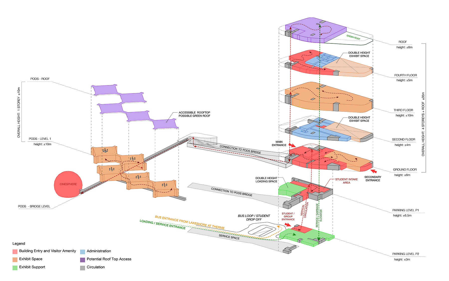
The recommended alternative for the OSC main building is to have a medium (3 to 6 storeys; up to 55% P1 site coverage) building within P1 on the Mainland. Below is an example of how the existing Science Centre programming could fit onsite within a new 3 to 6 storey building connected to the five Pods and the Cinesphere. The image below shows a conceptual 4-storey layout; however, this is not the final design and is subject to change following feedback and through detail design.
Conceptual Layout Based on the Recommended Alternative
Feedback/comments
This section is now closed.
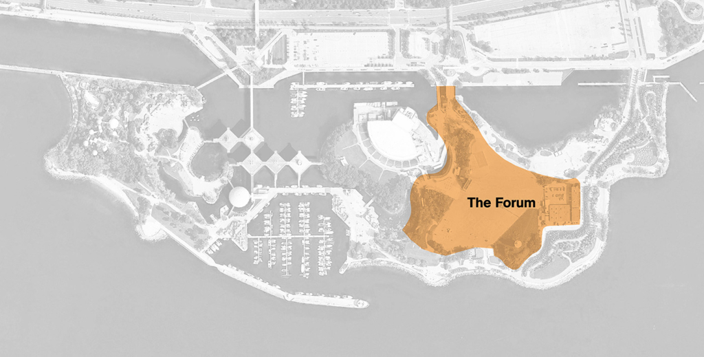
Zone 5: Forum
Forum: The concepts
The two concepts that were shared for the Forum in Fall 2022 and that were evaluated through the EA process are:
Forum: What we heard
✓ Flexible activity space
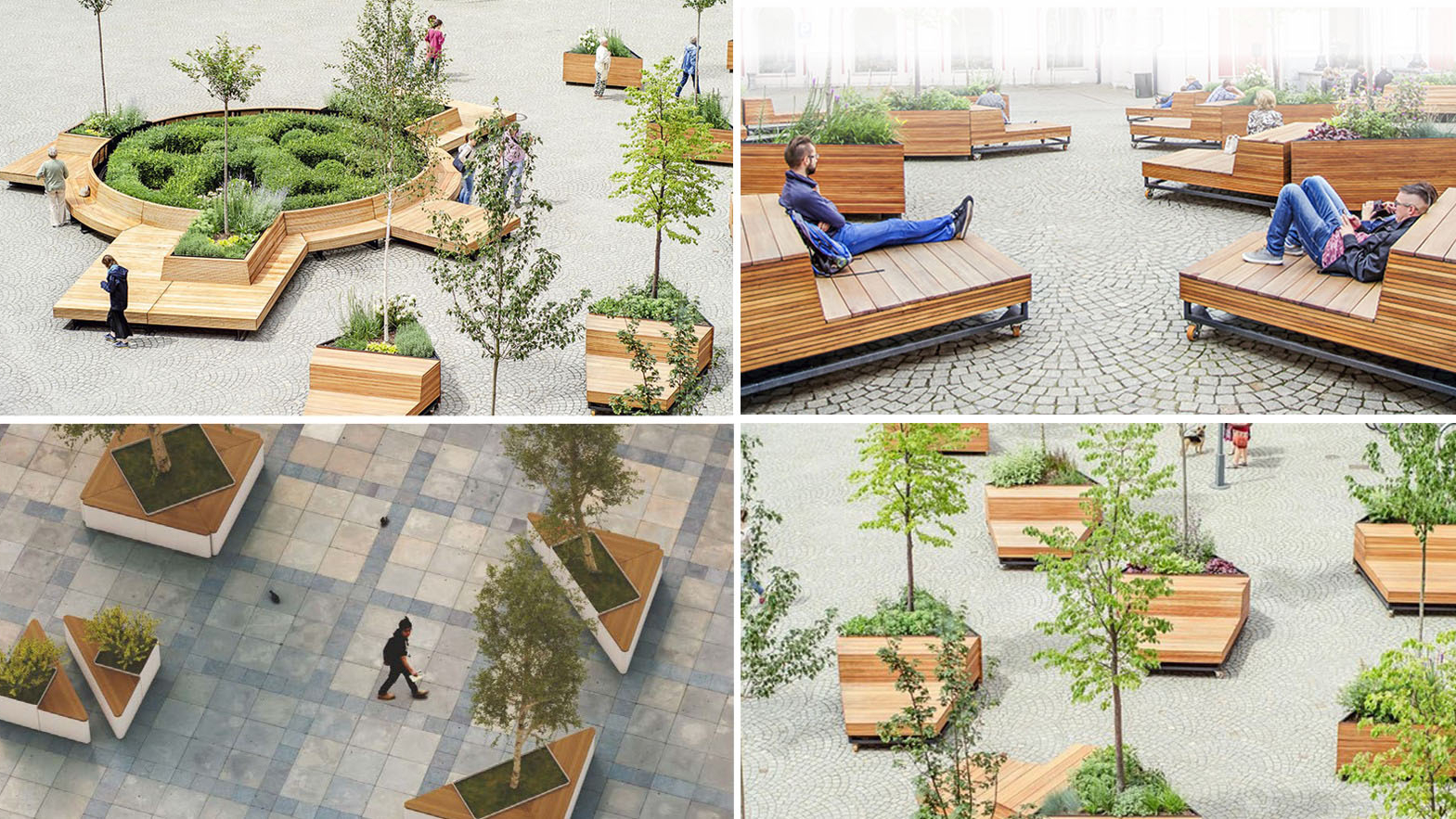
✓ Increase green areas; reduce paving
✓ Recreation for all ages, abilities, and genders
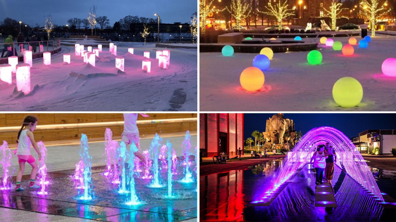
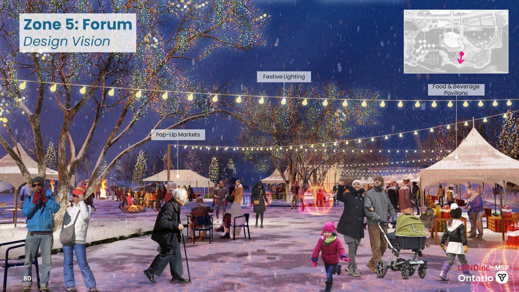
✓ Year-round and seasonal activities
✓ Combination of sports and leisure
Forum: The evaluation
| Category | Concept A: Fountain & Flexible | Concept B: Sports & Recreation |
|---|---|---|
| Natural Environment | Preferred | Preferred |
| Social Environment | Preferred | Less Preferred |
| Cultural Environment | Preferred | Preferred |
| Technical Environment | Preferred | Less Preferred |
| Economic Environment | Preferred | Less Preferred |
| Sustainability | Preferred | Less Preferred |
| Overall Preference | Preferred | Less Preferred |
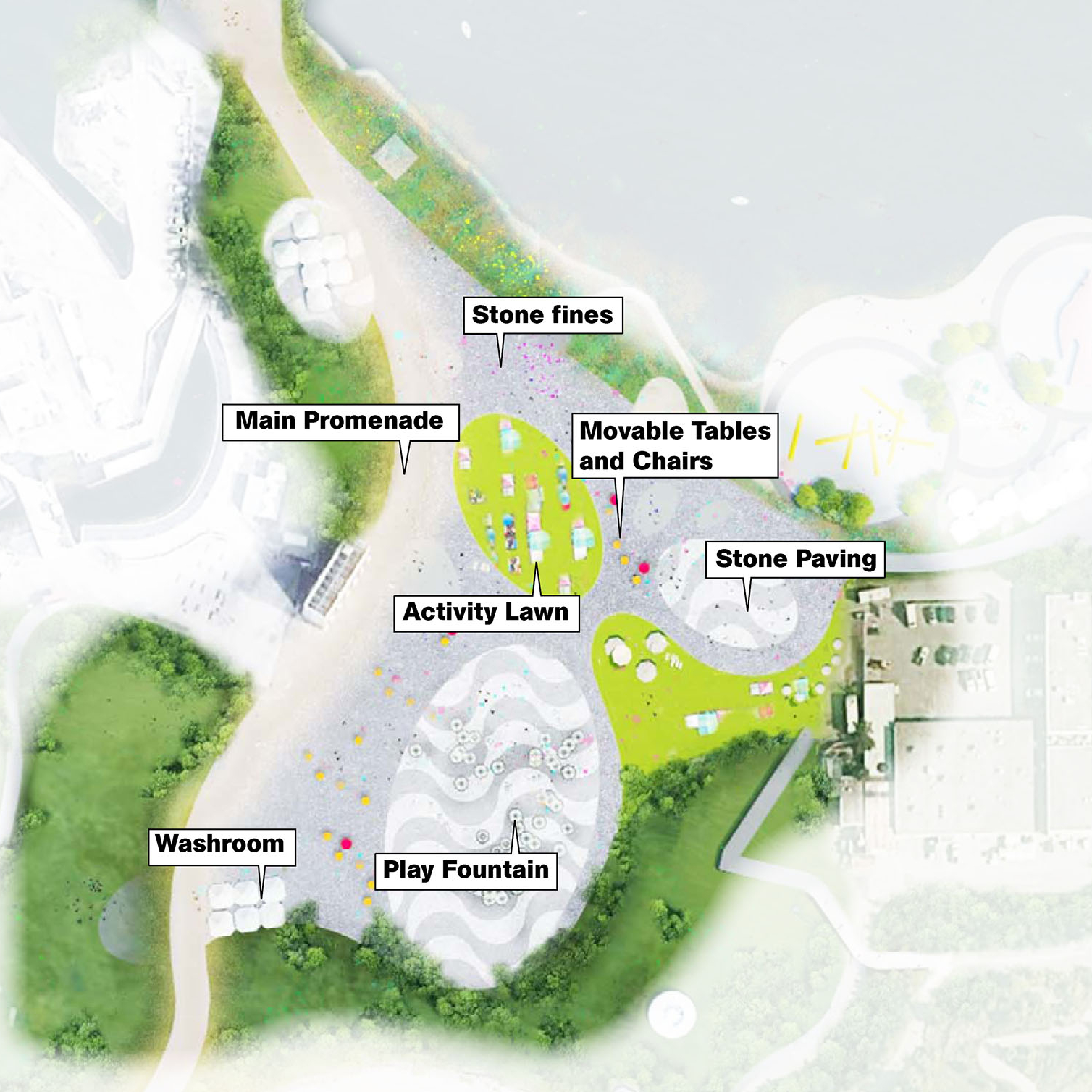
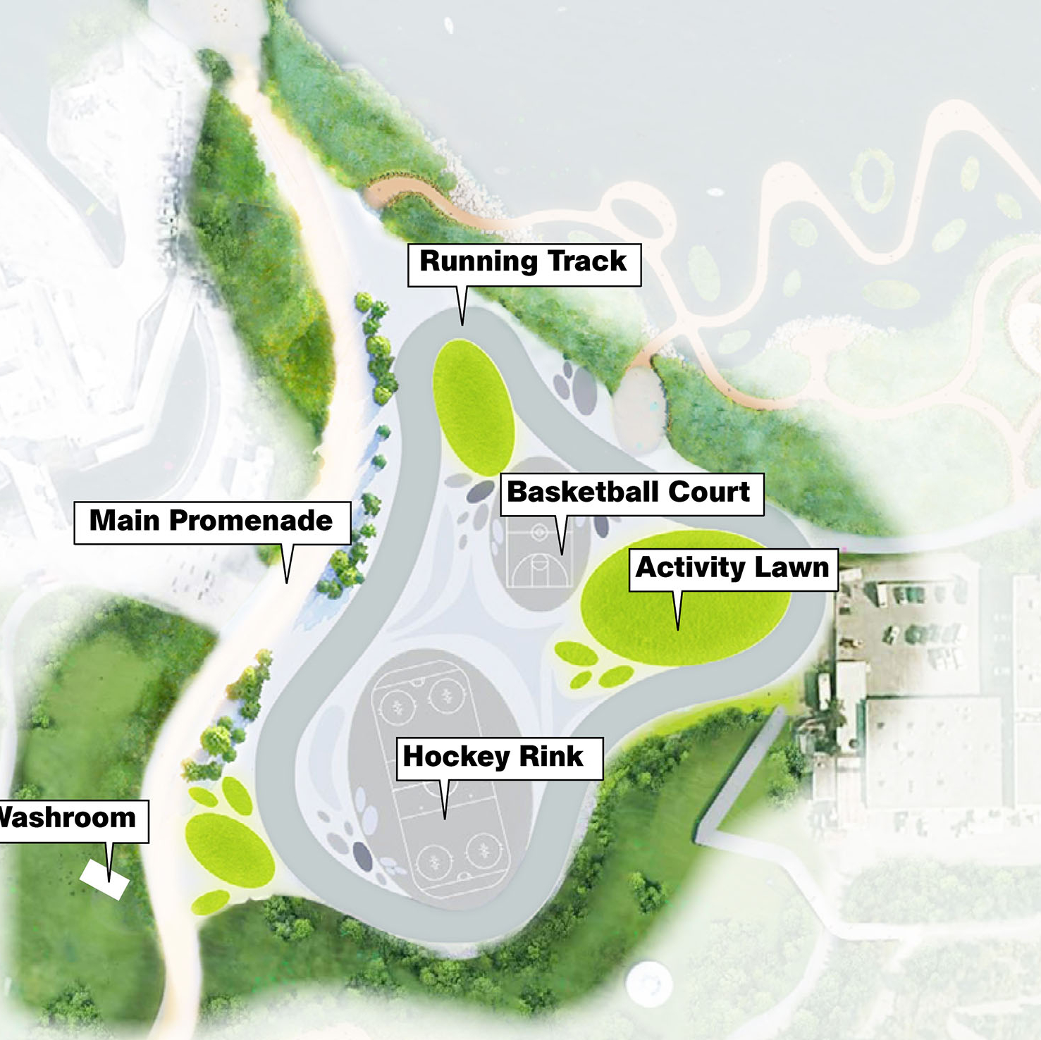
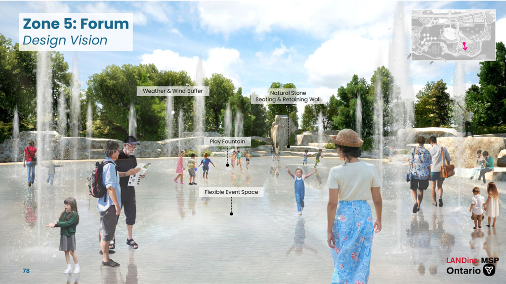
Concept A provides more flexibility and multi-use spaces (including for recreational-based use) while reducing the amount of impervious surface. The concept includes the installation of a Play Fountain, Flexible Sports Court and Stone Amphitheater. Concept A will include design modifications and incorporation of bioswales to better address stormwater management. A summary table of the evaluation of the design concepts for the Forum can be viewed here.
Forum: The recommended design
To accommodate a wide range of cultural, commercial and recreational events, we are aiming to maintain a flexible open space at The Forum. The forum is an event hub for both small and large events such as indigenous powwows, small concerts, art festivals, and more. The forum features an iconic 1-acre fountain for all ages to interact with or view from the rock bluff at the south edge of the forum. A proposed berm with appropriate vegetation is planned along the south edge of the forum to provide protection from south shore wind. A market alley activity space is included with temporary food and beverage. Connections from the Forum to the south shore to Trillium Park exist through a series of trails that wind through a forest landscape similar to Trillium Park.
Feedback/Comments
This section is now closed.
Bringing it all together
After the design concepts for each zone were evaluated and a recommended design was selected, they were brought together, and the entire site was then assessed for cohesiveness and balance between the zones. While some zones resulted in a natural recommended design with more green space, others took on a more recreational focus to create a balance of needs and wants for the site. Integration with private (tenant) developments was also considered in developing this overall recommended design.
Key public priorities
Different elements of what we’ve heard from the public is reflected in each zone. Overall, the range of feedback we’ve received has been reflected in the recommended public realm design. The recommended public realm design addresses the following key public priorities:
- Maintain unrestricted, free, and accessible entry to the park year-round
- Provide access to the shoreline and the water
- Consider climate change
- Protect wildlife, aquatic species and their habitat
- Increase greenspace with native plants; limit asphalt and paving
- Provide pathways for pedestrians and cyclists throughout the site
- Provide a variety of cultural and recreational opportunities
- Provide an ‘escape’ from the city
- Restore the ‘look and feel’ of the original Ontario Place (Zeidler and Hough designs)
- Honour Indigenous culture
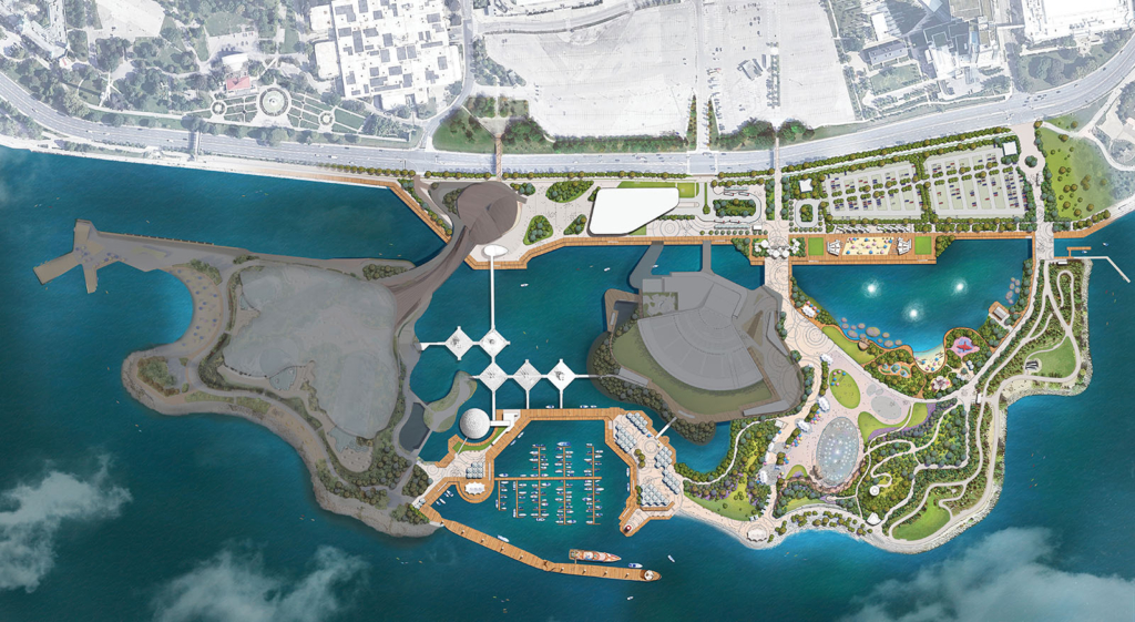
The overall EA recommended design
The design plan below shows the overall recommended design for the public realm lands. As a reminder, the shaded lands fall outside of the Category C EA study area. The EA process includes seeking input on this overall recommended design and based on the input received, modifications can be made to the recommended design. The preferred design for the public realm will be outlined in the Environmental Study Report, which will also be released for public comment in the summer.
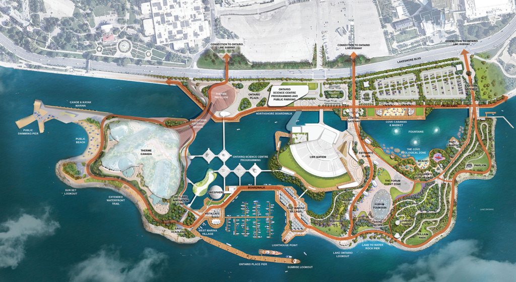
Overall redevelopment preliminary design
The design team has been working to ensure seamless integration with tenants and to provide continuous public access around the entire shoreline of the site. In the below design plan, linkages can be seen between the public realm lands (EA component) and all of the publicly accessible connections that will be provided throughout Ontario Place (indicated by the arrows). This design plan is a preliminary design for the overall redevelopment and is subject to change depending on comments received separately through the EA (applicable to the public realm) and development application (applicable to the tenant developments) processes.
Feedback/comments
This section is now closed.